Home -> Law Blog Directory -> Law Students Blogs -> Legally Blonde Ambition
(866) 635-2689 for Personal Injury or (866) 635-9402 for Criminal Defense
Find a Local Lawyer
Divorce (866) 635-6190
Personal Injury (866) 635-2689
Criminal Defense (866) 635-9402

Law Students
: Legally Blonde AmbitionMake Levees Not War*
By "Daisy Duke"


 And finally, a little close up of the city & its neighborhoods, with the main interstate, I-10, running through it. See how getting in & out of the city is a wee bit...limited? The green line over the Lake is the Causeway Bridge, featured on Modern Marvels as the longest bridges in the world by total length (23 miles long!!)
 This is what driving North over the Causeway looks like....you can see the massive Lake you are driving over, that eventually filled up New Orleans during Katrina:


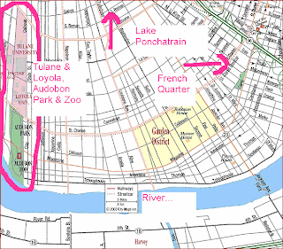 And here is the French Quarter area...see the small green square by the river? That is the Cathedral & Jackson Square area...see photo below.... My favorite building in the area is the old Cabildo building, which now houses a Louisiana/Mardi Gras museum:


 Many of the river levees are quite scenic- large grassy areas that are filled on the weekends with sunbathers, picnics, youth sports & crawfish boils. As technology grew more advanced however, the levees weren't really..updated. Or extended. Or raised.

Some of the levees were not over topped however (specifically I believe the 17th Street & London Canal) but instead, the flood walls didn't extend deep enough to withstand the pressure of the extra water. At the time Hurricane Katrina hit, it was the strongest storm on record in the Gulf (later surpassed by Rita, also in 2005). As it slammed to the east of New Orleans, the sheer strength of storm pushed a massive surge of water inland. Through the wetlands, up the rivers & into the lakes. And pretty soon it came from the lakes, over the levees and into the city:
Here is what a levee breach looks like, the water rushing over the breach, equalizing the two levels:

Once the levee is over topped or breached, the chain of events starts-and it isn't stopping until we can plug up the holes or the level of the water in the lake & the city equalize on both sides.If we can't fix the breach, we have to wait for equaliziation, plug up the hole & pump out the water. During Katrina, it was lake levees (actually levees in canals that were fed by lake water) that broke- not Mississippi River levees- and so the whole lake came pouring into the city, only stopping when the water levels were equal on both sides. See that barge in the right hand corner? 
You can see it in the top right hand corner of my photo, taken in the lower 9th Ward during the January after the storm- you can also see the Claiborne Ave. bridge...
....which is the same bridge these images were taken from during Gustav. Please note however, that in the Gustav images, the water is splashing over into the 9th Ward- the opposite side of the canal than Katrina. When driving along, you first pass through the 9th Ward, and then over the bridge, into the Lower 9th Ward. 
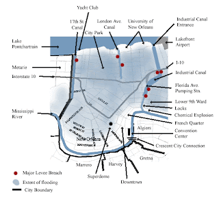
Here, I'll let this labeled image show you an aerial view of two of the breaches along that same Industrial Canal- you can see the bridge labeled, and the barge, as well as the Lower 9th Ward on the right hand side, and the 9th Ward on the left hand side:  This map shows you where the major levee breaches were during Katrina...you'll notice there were quite a few breaches along the Industrial Canal (4 total I believe)....the "Zoo" dot near the river on the left side of the map shows you where Uptown is (where there was no flooding). The airport, in Kenner is off the left. You can also see the Superdome & French Quarter dots:

 See the blue areas in the image above? That is where the water spread to, as the city-water level slowly equalized with the lake-water level. Which as we all know, turned the city into something like this:
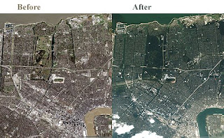 And this...basically the only white, "dry" areas are right along the river banks, whose levees held. The rest of the city took on water at a rapid & terrifying pace:
 And it turned New Orleans into this...the yellow house above was in Gentilly, I spent 3 days helping to gut it of the rotten filth it became as it soaked in the toxic water...and the white house, below, was in Lakeview. I spent one day helping to gut & bleach that one... notice the water lines on the car that was in the street. We unfortunately found & buried the dog of the family who called that white house home...
 This photo is of the Lower 9th Ward and shows the sheer power of the water as it rushed out of the lake and into the city:

So. There it is. The vulnerability of New Orleans...clear as mud I'm sure. Hopefully this helps some of you have a better mental picture of what all the fuss is/was/will be about.
After Katrina, New Orleans learned some valuable lessons, on both the necessity of the integrity of the levee system, and the necessity of information & evacuation. I'm proud that during Gustav people acted, stocking up on food & water, and the city actually helped get people out. Not to say it was perfect- it surely wasn't- but it was a huge step in the right direction. As for the unprecedented evacuation followed by a near-miss? Well, the forecasters were only off by about 30 miles as to where Gustav hit...which means that tiny margin of error, which allowed New Orleans to come through relatively unscathed, was just that- a tiny margin of error. 30 miles closer to New Orleans, and the levees, still undergoing strengthening & fortification (not to be finished until 2011) would have had a much harder time holding back the water.
Whew. I'm not sure I have any eloquent way to wrap that up, other than to say I pray the rest of the Tropical Storm Season goes out with a whimper...and I hope Hurricane Hanna stays far away from the coast of Georgia where my family is.
** Excellent question from Elle Woods. I didn't really explain the canals- which is where the levees were that broke. There were (I believe) 3 main canal levees that broke, all fed from Lake Pontchartrain. The canals served different purposes. The Industrial Canal links the Mississippi River & the Lake- with a lock down at the river end. Barges can also access the Gulf Intracostal Waterway from the Canal, which also has a harbor. There are proposals to build a damn at the Lake end to help prevent catastrophic flooding, but I don't believe any decisions have been made. In comparison, the London Avenue Canal is used to pump rain water into the Lake from the city, and the 17th Street Canal is drainage canal that runs through Metairie (Look the left of the maps for these canals, the Industrial Canal is the widest one on the right)
In theory I suppose the Industrial Canal is somewhat of a "funnel" to the city- it certainly the largest of these canals, with barges & tankers that travel through it, moving from the Lake to the River & vice versa, but I'm not particularly well versed on the issue beyond what I've stated here. Anyone know anything more than that??
Full post as published by Legally Blonde Ambition on September 02, 2008 (boomark / email).
Albertsons et al.
allegedly injected dye into farm raised salmon to make it appear more palatable.
Holiday Inn Express
Complimentary simplySmart™ "Remove" Make Up Remover Recalled
Cipro
The FDA is seeking to add black box warnings of the risk of tendon rupture associated with Cipro and Levaquin.
The ruptures can involve Achilles tendon, shoulder, hand, bicep or thumb tendons, and is especially increased in patients older than 60, or people who have received kidney, heart or lung transplants, as well as people on steroid therapy...

#1 Online Legal Resource

On 08-25 at 15:46PM
Acute perpendicular parking #NYPD #NYFD
On 08-18 at 22:18PM
Parallel parking gone bad. Too much gas UES NYC
On 08-18 at 21:41PM
UES NYC
On 08-18 at 21:25PM
Twitter suspends journalist critical of broadcast partner's coverage on dubious grounds @guyadams #nbcfail #twitterfail
On 07-30 at 17:57PM
Model example of 1st Amendment suppression by the People of New York City's Michael Bloomberg #OWS #NYPD
On 07-12 at 21:07PM
AG Holder lackadaisical on Operation in our Sites domain name seizures & RIAA lobbied free speech suppression @dajaz1
On 06-08 at 22:44PM
Why is the Catholic Church going to court over Obama contraception policy? @NewYorker commentary
On 05-31 at 10:08AM
Monks sue Louisiana for right to sell caskets made from forrest destroyed by Katrina
On 05-31 at 07:47AM
Are the abortion ultrasound laws headed for the Supreme Court?
On 05-15 at 21:52PM


West Bank Levees May Not Be High Enough to Handle Storm Surge.--
More on Levees; Eminent Domain
Water From Broken Levees Falls Within Insurance Policy Flood Exclusion
"Katrina Suit Vs. Army Corps Dismissed"
Insurers Racking Up the Wins in Katrina-Homeowner Litigation
Q: Who is Beaumont Vance, and what does he know


 |
|
Contact Us | About Us | Celebrity Law Blog |
Our Partners | Disclaimer
| Law Blog Directory
| Law Jobs
| Law Tweets
| Oil Spill Video
All original material © 1999-2011 by USLaw.com. All other material, including Blog Directory feed content, are © by their respective copyright holders. |